File:SR-Skyrim-Map-Grass-Pod.png
The UESPWiki – Your source for The Elder Scrolls since 1995

Size of this preview: 759 × 600 pixels. Other resolutions: 972 × 768 pixels | 3,808 × 3,008 pixels.
Original file (3,808 × 3,008 pixels, file size: 9.77 MB, MIME type: image/png)
Summary[edit]
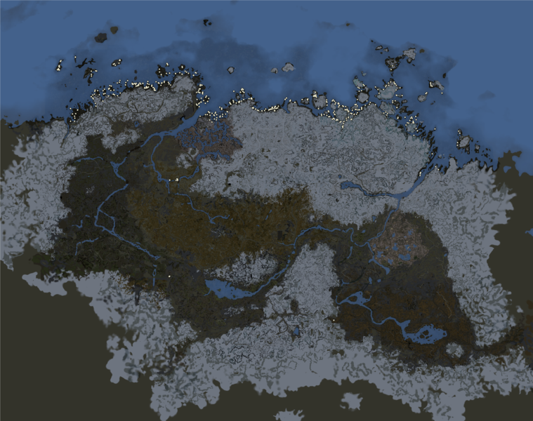
A map of all Grass Pod plants in Skyrim's overworld ([WRLD:0000003C]Tamriel), with all non-Creation Club DLCs loaded. Each dot represents at least one object; when several objects are clustered together in close proximity, they may look like just one dot. One can see that these plants grow all along Skyrim's northern coastline; a small cluster grows at the southern edge of Morthal's swamps.
This map was generated automatically. Aside from marked locations, only heightmapped terrain and cell water (not placed water activators) are shown.
Licensing[edit]
 |
This image was created for use on UESP using components taken from the Elder Scrolls series of video games or from websites created and owned by Bethesda Softworks. The copyright for the components is held by Bethesda Softworks while the copyright for this particular composition is held by UESP. It is available for use under the same Attribution-ShareAlike 2.5 License as our text content. For further details, see our copyright policy. |  |
File history
Click on a date/time to view the file as it appeared at that time.
| Date/Time | Thumbnail | Dimensions | User | Comment | |
|---|---|---|---|---|---|
| current | 16:43, 7 October 2021 |  | 3,808 × 3,008 (9.77 MB) | DavidJCobb (talk | contribs) | A map of all Grass Pod plants in Skyrim's overworld (<code>[WRLD:0000003C]Tamriel</code>), with all non-Creation Club DLCs loaded. Each dot represents at least one object; when several objects are clustered together in close proximity, they may look li... |
- You cannot overwrite this file.
File usage
The following page links to this file: